In order to accommodate vital infrastructure works at the Liverpool Terminal sailings are being altered.
Liverpool Mooring works March 14th - 22ndWait for no man …can be timetabled
Travellers who regularly sail on our service to Heysham may have noticed on occasion the ship departs and arrives at times that differ to the ‘usual’ timetable. The most common reason for this scheduled timetable change is due to the predicted low tides in Heysham Port.

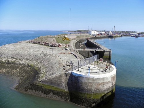
Any vessel must have sufficient water to be able to float and navigate safely. The tidal range in Heysham can be as much as 9m and if unchecked could lead to a ship’s grounding in low water depths. Luckily as any experienced seafarer can tell you, the tides can accurately be predicted.
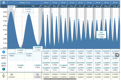
Source: https://www.tide-forecast.com/locations/Heysham-England/tides
Determining the tidal height at a specific date/time at a particular port can easily be done using modern tide tables or software. The chart above indicates Heysham at 0914 on the 17 July 2022 with a tidal height of 1.08m. Note later on at 1452 the tidal height is 9.2m – plenty of water for the Ben-my-Chree’s turnaround in Heysham.
The Steam Packet Company, as part of the Isle of Man Merchant Shipping (SOLAS Chapter V)(Safety of Navigation) Regulations, has recently completed a project analysing the tides in Heysham for every day of next year to ensure the safety of the ship. This this means checking the available depth of water and related to this is the height of the tide with information obtained by information from the UK Hydrographic Office as well as the local port authority. The results of this project is one of a number of factors that help the company determine a reliable timetable.
Where the predicted tides in Heysham port are too low for sufficient water underneath the ship (under keel clearance), the sailing time is amended to get around this. Sometimes the departure time from Douglas is brought forward to arrive Heysham before a certain time on a falling (ebbing) tide.
Frequently the departure time from Heysham is brought forward to clear the port before a certain time on a falling (ebbing) tide. At other times the ship will depart Douglas on time but will arrive Heysham slightly later on a low rising (flood) tide. In these circumstances every minute counts so efforts to avoid delays are crucial. In extreme cases the ship’s draught may also be reduced by deballasting to help maintain a safe under keel clearance.
Unfortunately, this is not always as straightforward as it appears to be, and as if that’s not complicated enough weather, which cannot be predicted as far in advance, can also have a major influence.
On days where there is high air pressure this can cause a lower than predicted tidal height, in effect by ‘pushing’ down the water. Additionally, the shifting sands of the seabed in the Morecambe Bay area means the charted water depths (chart datum) can change. This can also occur significantly after storms in the area. To monitor the changing seabed the port authority in Heysham regularly surveys (measures the water depths by soundings) the approaches and harbour area. From these surveys a sounding chart is produced indicating new charted water depths in a localised area.
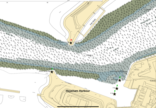
A section of the latest sounding chart for the entrance at Heysham port. The chart indicates the latest chart datum determined by survey. The chart datum is the plane below which the level of water very rarely falls. Add on top the tidal height and you have the total depth of water.
Based on the latest charted water depth information available, together with the predicted tides and company required under keel clearance, the timetable is assessed and only if necessary is amended. Where a published timetable requires amending the Steam Packet Company always tries to ensure passengers are informed in plenty of time.
You may be aware of dredging operations in and around the Heysham port area. Dredging helps maintain suitable water depths in the port region. This takes time to complete and needs to be resurveyed then charted before the new charted water depths can be factored in to our timetable.
As a safety check our company safety procedures ensure the water depths, tides, ship’s draught and under keel clearance are closely monitored and checked for every departure sailing.
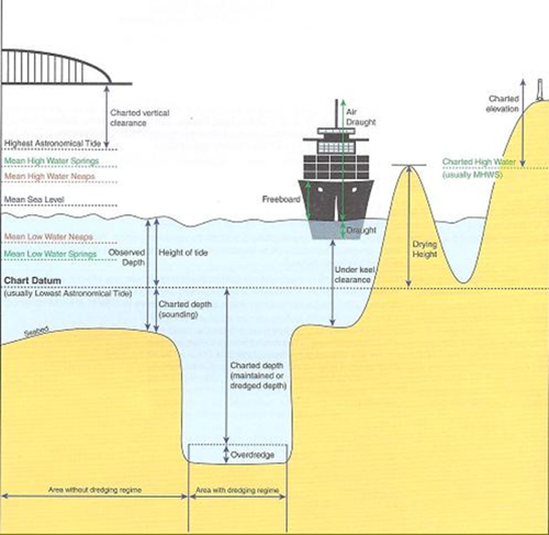
Number crunching is part of our departure checklist. Calculating sufficient water is available for safe navigation throughout the voyage is one of our many important safety checks carried out prior to every departure. Luckily, we have no low bridges or drying heights on our routes to contend.
Next time you’re on the ship in Heysham that has a different timetable to normal take a look at the low water depth in Heysham port. Think of the Captain skilfully manoeuvring the ship in the low water and the work that has been done to prepare for this to ensure safe navigation and provide a continuous service.
Get the latest deals and offers
Join our mailing list to receive early-bird offers, exclusive deals and travel inspiration.
